


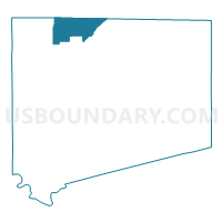
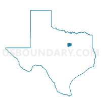
Voting District 0032, Johnson County, Texas
About
Outline

Summary
| Unique Area Identifier | 675136 |
| Name | Voting District 0032 |
| County | Johnson County |
| State | Texas |
| Area (square miles) | 21.74 |
| Land Area (square miles) | 21.71 |
| Water Area (square miles) | 0.03 |
| % of Land Area | 99.88 |
| % of Water Area | 0.12 |
| Latitude of the Internal Point | 32.53982400 |
| Longtitude of the Internal Point | -97.45975020 |
Maps

Graphs
Select a template below for downloading or customizing gragh for Voting District 0032, Johnson County, Texas


Neighbors
Neighoring Voting District (by Name) Neighboring Voting District on the Map
- Voting District 0001, Johnson County, TX
- Voting District 0002, Johnson County, TX
- Voting District 0003, Johnson County, TX
- Voting District 1023, Tarrant County, TX
- Voting District 1103, Tarrant County, TX
- Voting District 1294, Tarrant County, TX
- Voting District 1348, Tarrant County, TX
- Voting District 1447, Tarrant County, TX
Top 10 Neighboring County Subdivision (by Population) Neighboring County Subdivision on the Map
- Fort Worth CCD, Tarrant County, TX (791,745)
- Burleson-Joshua CCD, Johnson County, TX (53,895)
- Godley CCD, Johnson County, TX (4,035)
Top 10 Neighboring Place (by Population) Neighboring Place on the Map
Top 10 Neighboring Unified School District (by Population) Neighboring Unified School District on the Map
- Crowley Independent School District, TX (86,222)
- Burleson Independent School District, TX (52,131)
- Joshua Independent School District, TX (23,803)
- Godley Independent School District, TX (7,057)
Top 10 Neighboring State Legislative District Lower Chamber (by Population) Neighboring State Legislative District Lower Chamber on the Map
- State House District 96, TX (231,782)
- State House District 58, TX (169,146)
- State House District 97, TX (168,045)
Top 10 Neighboring State Legislative District Upper Chamber (by Population) Neighboring State Legislative District Upper Chamber on the Map
Top 10 Neighboring 111th Congressional District (by Population) Neighboring 111th Congressional District on the Map
Top 10 Neighboring Census Tract (by Population) Neighboring Census Tract on the Map
- Census Tract 1302.04, Johnson County, TX (9,890)
- Census Tract 1110.16, Tarrant County, TX (9,243)
- Census Tract 1110.08, Tarrant County, TX (7,216)
- Census Tract 1302.12, Johnson County, TX (4,714)
- Census Tract 1302.14, Johnson County, TX (4,693)
- Census Tract 1302.13, Johnson County, TX (4,341)
- Census Tract 1301, Johnson County, TX (4,035)
- Census Tract 1302.15, Johnson County, TX (3,911)
- Census Tract 1110.10, Tarrant County, TX (2,841)
- Census Tract 1110.15, Tarrant County, TX (2,385)
Top 10 Neighboring 5-Digit ZIP Code Tabulation Area (by Population) Neighboring 5-Digit ZIP Code Tabulation Area on the Map
- 76028, TX (59,744)
- 76036, TX (22,352)
- 76126, TX (19,395)
- 76058, TX (17,123)
- 76044, TX (3,866)
- 76035, TX (1,622)